

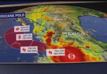
















Hurricane Polo intensifies to become a strong Category 4 Hurricane in the waters off Mexico’s Pacific coast, becoming one of the most outstanding cases of intensification in the 2026 Eastern Pacific hurricane season.
The storm reached maximum sustained winds of around 165 mph (266 km/h) while remaining offshore, according to the latest reports from the National Hurricane Center and Associated Press.
Hurricane Polo Intensifies to a Category 4 in the Waters Near Mexico as Another Hurricane is Born:
Polo’s explosive strengthening has drawn particular attention because the hurricane intensified extraordinarily quickly.
Forecasters have pointed to very warm Pacific Ocean waters, abundant moisture and favorable atmospheric conditions as key ingredients behind the storm’s rapid development.
Although Polo’s core is expected to remain offshore, its enormous circulation is still capable of producing dangerous rainfall, flooding, mudslides, powerful surf and rip currents along portions of Mexico’s Pacific coastline.
At the same time, another tropical system, Tropical Storm Odalys, has been strengthening far to the west and was forecast to become a hurricane, adding another layer of interest to an already active Eastern Pacific.
This article reflects weather information available on September 22, 2026. Hurricane forecasts can change quickly, so residents should rely on the National Hurricane Center and local Mexican authorities for the latest warnings.
Hurricane Polo Rapidly Explodes Into a Category 4 Storm:
Hurricane Polo’s transformation has been exceptionally fast.
The storm was only a tropical storm when it formed off southwestern Mexico on September 20. At that time, Polo had maximum sustained winds of about 40 mph.
Within roughly a day, it had strengthened into a hurricane, and its winds continued climbing at an extraordinary pace.
By early September 22, the National Hurricane Center reported Polo approaching Category 4 strength, with winds near 150 mph and a central pressure of approximately 935 millibars.
Later reports placed Polo firmly in Category 4 territory, with sustained winds reaching approximately 165 mph.
That represents a dramatic increase from the storm’s initial strength. Meteorologists use the term rapid intensification when a tropical cyclone’s maximum sustained winds increase by at least 30 knots, or about 35 mph, within 24 hours.
Polo’s development has been far more dramatic than that threshold. The National Hurricane Center described Polo’s recent strengthening as remarkable, noting that the storm gained roughly 90 knots of intensity in 24 hours in one of its advisories.
Polo Is an Extremely Dangerous Category 4 Hurricane:
Category 4 is the highest classification on the Saffir-Simpson Hurricane Wind Scale.
Category 4 hurricanes have sustained wind speeds that reach a minimum of 157 miles per hour (252 kilometers per hour).
In cases of high wind speeds, buildings may face catastrophic destruction while trees may get uprooted. Polo’s reported winds of approximately 165 mph place it above the Category 4 threshold.
The Associated Press described the storm as an “extremely dangerous” Category 4 hurricane as it moved slowly northward off southwestern Mexico.
However, the Category 4 classification describes wind intensity. It does not mean every location near the storm will experience Category 4 winds.
That distinction is particularly important with Polo because its strongest winds are concentrated around the hurricane’s compact inner core, while the storm itself remains offshore.
For Mexico, the most immediate concerns include rainfall, flooding, mudslides, dangerous coastal conditions, and tropical-storm-force winds rather than a direct Category 4 landfall.
Where Is Hurricane Polo Right Now?
Polo is positioned over the eastern Pacific Ocean, south of Mexico’s southwestern coast. Recent reports placed the storm roughly 200 to 220 miles south of Zihuatanejo, Mexico, with the hurricane moving slowly.
Reuters reported that Polo was also hundreds of miles south of Manzanillo. The storm’s position offshore is important because it reduces the likelihood of the hurricane’s most powerful winds directly striking the Mexican coastline.
However, offshore does not mean harmless.
A major hurricane can generate enormous amounts of rainfall and ocean swell well away from its exact center.
Coastal communities can therefore experience dangerous conditions even when the eye never reaches land.
The National Hurricane Center had warned that Polo would move slowly near the Mexican coast, making rainfall and coastal hazards important concerns.
Why Did Hurricane Polo Strengthen So Quickly?
One of the biggest questions surrounding Hurricane Polo is why it became so powerful in such a short period.
The solution to the question is based on a number of factors in both the atmosphere and oceans acting together. Excessively Warm Water in the Ocean
Ocean waters that are warm give heat that tropical cyclones can utilize for their intensification.
Some of the information that has been documented concerning Tropical Cyclone Polo suggests unusually high temperatures of more than 87°F (around 31°C) in the Pacific Ocean within the region where the tropical cyclone was forming.
That process can help lower atmospheric pressure and strengthen the circulation of a tropical cyclone. Polo developed in an environment where this process could operate very efficiently.
Low Wind Shear:
Another important ingredient was relatively favorable vertical wind shear. Wind shear refers to changes in wind speed or direction with height.
High wind shear is capable of disturbing a hurricane by making the circulation system tilted and detaching the storms from the center.
Low wind shear, by contrast, can allow a tropical cyclone to maintain a more vertically aligned structure. Polo developed under conditions that allowed its circulation to organize rapidly.
Abundant Atmospheric Moisture:
Moisture is another major factor. To sustain the thunderstorm environment, a tropical cyclone requires a constant input of warm and humid air at its core.
When dry air gets into a storm system, it may affect its convective process and organization. Polo benefited from an environment rich in moisture, helping its thunderstorms remain concentrated around the developing eye.
Polo’s Rapid Intensification Could Set an Eastern Pacific Record:
The speed of Polo’s strengthening has generated comparisons with previous rapid-intensification events in the Eastern Pacific.
The San Francisco Chronicle reported that Polo may have strengthened from a 40-mph tropical storm to a 160-mph Category 4 hurricane in roughly 36 hours.
If confirmed by post-storm analysis, that could challenge the previous record for the fastest strengthening in the Eastern Pacific, which has been associated with storms including Elida, Willa and Jova.
There is an important distinction between preliminary storm intensity estimates and final historical records.
Meteorological agencies often conduct detailed post-season analyses of tropical cyclones. Satellite observations, aircraft measurements, surface observations and other data can be reviewed to determine the storm’s final intensity history.
Therefore, claims that Polo has definitively broken a record should be treated as preliminary until official historical analysis confirms them. Still, even without a confirmed record, the storm’s strengthening rate has been extraordinary.
Mexico Faces Heavy Rain, Flooding and Mudslide Threats:
The greatest threat from Polo to Mexico may not be the hurricane’s strongest winds.
Instead, heavy rainfall and resulting flooding and mudslides are major concerns.
The National Hurricane Center forecast rainfall totals of roughly 4 to 8 inches across portions of Guerrero and Michoacán, with isolated amounts potentially reaching 12 inches.
Coastal portions of Oaxaca, Colima and Jalisco could also receive several inches of rain.
Heavy tropical rainfall becomes especially dangerous when it falls over mountainous terrain. Water can swiftly flow down the slope, resulting in:
- Flash floods
- Flooding of rivers and streams
- Mudslides
- Rockslides
- Road closures
- Dangerous traveling conditions
- Damage to property
This issue becomes especially dangerous due to intense rainfall in hilly areas on the Pacific coast of Mexico.
Guerrero and Michoacán Among the Areas Watching Polo Closely:
Guerrero and Michoacán are among the Mexican states facing significant rainfall risks from Polo.
The National Hurricane Center warned that rainfall could produce life-threatening flooding and mudslides, especially in areas with steep terrain. Coastal areas of Oaxaca, Colima and Jalisco were also included in rainfall forecasts.
See also Perez Hilton Hospitalised After Alarming TikTok Livestream
Because Polo was expected to move slowly, rainfall could persist in affected areas rather than passing quickly.
For residents, this means that the storm’s center does not have to make landfall for serious weather impacts to occur.
People living near rivers, streams, hillsides, and areas with a history of flooding should pay close attention to official emergency instructions.
Dangerous Surf and Rip Currents Are Another Major Threat:
Hurricanes affect coastal areas in more ways than wind and rain. Polo is generating large swells and dangerous surf along parts of Mexico’s Pacific coastline.
The National Hurricane Center warned that swells generated by Polo could create life-threatening surf and rip-current conditions.
Rip currents can pull swimmers away from shore with surprising force. Even when skies appear relatively calm at a particular beach, distant hurricanes can send powerful waves and swells toward the coast.
For this reason, people visiting the beaches should never use rainfall and winds in the locality as an indicator of the weather at sea.
Will Hurricane Polo Make Landfall in Mexico?
Current forecasts indicated that Polo’s core was expected to remain offshore, rather than making a direct landfall as a Category 4 hurricane.
That does not eliminate the threat. Forecast tracks can change, especially when a tropical cyclone is interacting with surrounding weather systems. The National Hurricane Center emphasized uncertainty in the storm’s exact future impacts.
Polo’s strongest winds were concentrated near its center, so keeping the eye offshore could significantly reduce the risk of catastrophic hurricane-force winds directly affecting Mexico.
But rainfall, surf, rip currents and tropical-storm-force winds can extend considerably beyond the eye.
Therefore, coastal communities should continue following official forecasts even if the projected track remains offshore.
Another Tropical System, Odalys, Adds to the Pacific Activity:
While Polo has dominated attention, another storm has been developing in the Eastern Pacific.
Tropical Storm Odalys formed farther west of Mexico and has been strengthening. The National Hurricane Center reported that Odalys was located far southwest of the southern tip of Baja California and was expected to turn toward the east-northeast and eventually northeast.
Early Tuesday, Odalys had maximum sustained winds near 65 mph, and forecasters expected additional strengthening, with the possibility of becoming a hurricane later Tuesday or Tuesday night.
Unlike Polo, Odalys was not posing an immediate coastal threat at that stage. Nevertheless, having two tropical systems in the Eastern Pacific at approximately the same time can make the overall forecast more complicated.
Could Polo and Odalys Interact?
Polo and Odalys were closely monitored by forecasters due to the potential impact one may have on the other.
When two tropical cyclones are near each other, there may be some interaction between them due to their circulation patterns. This is what experts refer to as the Fujiwhara effect.
Reports indicated that Polo’s track could eventually be affected by its proximity to Odalys.
That does not automatically mean the two hurricanes will merge or dramatically change one another.
Forecast models must account for multiple atmospheric features, including steering currents, upper-level troughs, and the circulation of nearby tropical systems.
Consequently, the future path of Polo and Odalys remains something meteorologists must continue monitoring.
Hurricane Polo and the 2026 Eastern Pacific Hurricane Season:
Polo arrived during an active period for the Eastern Pacific hurricane season. The National Hurricane Center’s seasonal summary showed that by September 22, the basin had recorded 16 named storms, five hurricanes and two major hurricanes.
Polo was the 17th tropical cyclone of the season in the Eastern Pacific naming sequence, following Odalys in the season’s chronology.
The 2026 season has also featured several powerful hurricanes, including earlier major hurricanes such as Genevieve, Karina, and Lowell.
Polo’s arrival therefore comes during a period when tropical activity remains significant across the Pacific.
The Potential Role of El Niño in the Pacific Region:
Another major contributor to the 2026 weather narrative is El Niño.
El Niño refers to the warming phenomenon in certain regions of the tropical Pacific, which may influence global atmospheric circulation.
It has been observed that the presence of such a warm oceanic environment has provided a conducive environment for the development of tropical cyclones.
But El Niño is not synonymous with an increase in storm intensity. Several different elements like ocean temperature, wind shear, moisture, atmospheric stability, and structure of the storm determine the intensity of a hurricane.
In the case of Hurricane Polo, there seem to be a number of favorable elements working simultaneously.
The Rarity and Destructive Potential of Category 4 Hurricanes:
Category 4 hurricanes indicate the upper limit of the Saffir-Simpson wind scale.
This means wind speeds of 157 mph or higher. A Category 4 hurricane carries a large amount of energy and poses catastrophic wind damage if the eyewall moves over land areas.
Yet Category 4 status should not be interpreted as a prediction of total damage. A Category 4 hurricane remaining hundreds of miles offshore can have a very different impact from a Category 4 hurricane making a direct landfall in a densely populated region.
Polo’s situation demonstrates this distinction clearly. Its maximum winds are extreme, but its offshore track means that rainfall, flooding, and coastal hazards may be more relevant to Mexico than a direct strike from its most powerful winds.
What the People of the Pacific Coast of Mexico Should Watch For
The residents in the affected regions should get updates from the Mexican government authorities and the National Hurricane Center.
The main things that need to be watched are:
Heavy rains: It may continue even though the hurricane center is still out at sea.
Flash floods: This may occur in lowlands and river valleys.Mudslides: The saturated ground can lead to mudslides, especially in case of prolonged heavy rains.
Strong winds: Tropical-storm-force winds may damage trees, signs, and loose objects.
High waves: It makes the beaches dangerous.
Rip currents: These may form even away from the center of the storm.
People should stay away from flooded roads and do not enter fast-flowing water. They should secure any loose objects and follow instructions for evacuation or shelters issued by the authorities.
Hurricane Polo Shows Us What Changes Tropical Storms Can Undergo Quickly:
It may be that one of the most surprising facts about Polo is how fast a tropical cyclone can change.
At the beginning, it was just a typical tropical disturbance. Very soon it became a hurricane and continued to grow into a Category 4 hurricane with winds greater than 160 mph.
That is the reason why meteorologists are constantly tracking tropical disturbances.
The forecast, which would have been made one day before, could be totally different due to the latest satellite information, airplane measurements, and atmospheric data. Residents need to pay attention to current warnings, official forecast updates, and local emergency instructions.
Frequently Asked Questions About Hurricane Polo:
Is Hurricane Polo a Category 4 hurricane?
Yes, according to September 24 information, Polo became a Category 4 hurricane, with 165 mph winds.
Is Hurricane Polo expected to hit Mexico directly?
Current forecasts indicated that Polo’s core would remain offshore, although the storm could still produce dangerous rainfall, surf, rip currents, and strong winds along parts of Mexico’s Pacific coast.
Which Mexican states are most at risk from heavy rain?
Guerrero and Michoacán were among the areas facing the greatest rainfall concerns, while portions of Oaxaca, Colima and Jalisco could also experience significant rain.
How strong is Hurricane Polo?
On September 22, the maximum sustained winds of Tropical Storm Polo were estimated to be about 165 mph (266 km/h).
What is Tropical Storm Odalys?
Odalys is another Eastern Pacific tropical cyclone that developed west of Mexico. On September 22, it had winds near 65 mph and was forecast to strengthen further, potentially becoming a hurricane.
What caused such a fast intensification of Polo?
Polo formed above exceptionally warm water, under conditions that included high moisture content and suitable winds.
Final Thoughts on Hurricane Polo:
Hurricane Polo’s quick evolution into a Category 4 hurricane ranks among the most amazing weather phenomena of the 2026 Eastern Pacific hurricane season.
With winds of 165 mph, extremely fast intensification, and very slow movement close to the Mexican Pacific coast, this storm has become a subject of intense interest for meteorologists and officials.
Fortunately, the latest forecasts indicated that Polo’s core would remain offshore rather than making a direct Category 4 landfall.
Nevertheless, dangerous rainfall, flooding, mudslides, powerful surf and rip currents remain serious concerns for parts of southwestern Mexico.
The simultaneous development of Tropical Storm Odalys adds another interesting element to the Pacific weather pattern, although Odalys was farther offshore and did not pose an immediate coastal threat at the time of the latest available reports.
As Hurricane Polo continues across the Pacific, its exact track and intensity can change. It would be wise to stay tuned to the information being provided by the National Hurricane Center, the government of Mexico, and local weather forecasters, especially concerning rain, floods, and coastlines.


